About the Tool
Ursa Space has created a Python toolbox for satellite analytic and data ordering within Esri ArcGIS Pro, a full-featured professional desktop GIS application.
The tool allows you to task available satellite imagery, choosing from our current providers – Capella and ICEYE – both of which operate synthetic aperture radar (SAR) satellites. To order, you’ll define an area of interest, time and satellite provider, and then hit the order button; the prices are on our Virtual Constellation Pricing Sheet. You’ll receive a confirmation email from us, and then a follow-up email with the deliverable attached, which can be imported and viewed in ArcGIS Pro.
Esri software is deployed in more than 350,000 organizations globally, while Ursa Space leverages the world’s largest commercial satellite network to create analytic products across market verticals.
About Ursa Space
Ursa Space maintains robust partnerships with existing and upcoming commercial data providers, and regularly ingests and processes a variety of SAR and non-SAR (i.e. optical, infrared, multi-spectral, and hyperspectral) data. This collection of data partners is referred to as Ursa’s Virtual Constellation.
Ursa Space performs this processing through the development and deployment of the Ursa Platform. This platform contains the data and software services required to ingest data, run analytics and algorithms on these data to produce results, and provide customer access to related data feeds via API.
This toolbox is a plugin for ArcGIS Pro that permits easier access to Ursa’s Platform APIs to download SAR and optical imagery.
Requirements to Use the Toolbox
-
ArcGIS Pro needs to be installed and fully licensed
-
Ursa Platform credentials set to Invoice Only
-
New customers are required to submit this form to begin our verification process.
-
Existing customers can download from our GitHub repository and get started. Follow the instructions in the Installation section of this document.
-
Please note: all users must have the "Invoice Only" customer type. Please contact support@ursaspace.com to verify the customer type.
-
-
Administrative privileges must be granted if ArcGIS Pro is installed at the system level
-
If there is a lack of Admin access, a clone of the default ArcGIS Pro Python Environment must be created in a directory that does not require Admin access. See Esri's documentation for more details.
-
-
This toolbox only uses packages available in the default Python environment shipped with ArcGIS Pro.
Downloading From Our Repository
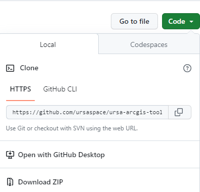
Navigate to the GitHub repository and click on the green Code button for options. From here, download the repository as a ZIP file or via a command-line tool.
The next section, Installation, will assume the repository was downloaded as a ZIP file.
Installation
-
Unzip the compressed file to the desired location.
-
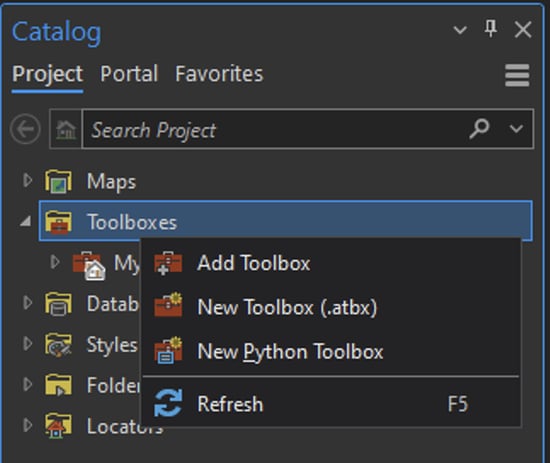
In an ArcGIS Pro document, open the Catalog.
-
Within the Catalog pane, right-click on Toolboxes and select Add Toolbox.
-
Using the navigation dialog box, navigate to the UrsaPlatform.pyt file located in the uncompressed repository folder and click “OK” to finalize the changes.
-
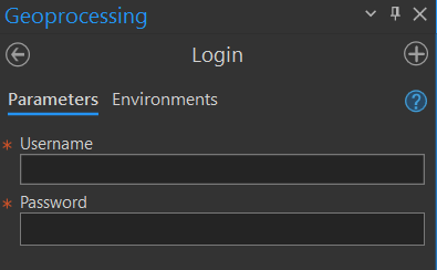
Open the added toolbox. There are three tools listed: Login , Tasking and Analytics.

Our custom toolbox will be saved into the Catalog pane once the project is saved. If a project is started from a blank template, the toolbox will have to be added again.
Usage
This toolbox assists in tasking and analyzing SAR and optical imagery that can be useful for visualizing an area. Ursa Space has multiple agreements with satellite vendors to ensure a robust collection of coverage across the world.
Inside of the toolbox, there are three tools: Login, Tasking and Analytics.
Login
The Login tool is what the name suggests: to log in to the Ursa Platform service using the user credentials. Running this tool is a mandatory step to use the other two tools in the toolbox.
Each session lasts up to 8 hours. If there is an authentication error, please verify the time limit has not elapsed. If the time limit has not been exceeded, contact support@ursaspace.com to open a ticket.
Tasking
The Tasking tool is used to browse and order from the imagery catalog.

Parameters
- Area of Interest (AOI): When entering in the dimensions of the AOI, the field requires a point geometry. This point can then be buffered by a certain size (by kilometers).
- Start date: Cannot be any earlier than 48 hours in the future from the current date and time.
- End date: Cannot be earlier than the start date.
- Imaging mode: This is where the image resolution is chosen. Can choose between SPOTLIGHT (between 0.5 meters and 1.5 meters) and STRIPMAP (between 0.5 meters and 3.5 meters).
- Vendor: Can choose between CAPELLA and ICEYE, or both.
Analytics
Once the images have been ordered and delivered, the Analytics tool helps to order and process the analytics for the AOI. Analytics include vessel detection, aircraft detection, ground vehicle detection, car counting, change detection, subsidence monitoring, and object detection.
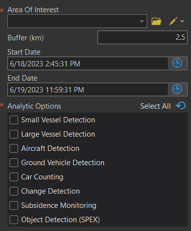
Parameters
-
Area of Interest: When entering in the dimensions of the AOI, the field requires a point geometry. This point can then be buffered by a certain size (by kilometers).
-
Start date: Cannot be any earlier than 48 hours in the future from the current date and time.
-
End date: Cannot be earlier than the start date.
-
Analytic Options: Analytics include vessel detection (small and large), aircraft detection, ground vehicle detection, car counting, change detection, subsidence monitoring, and object detection.
Pricing, Terms and Conditions
For pricing insights, please refer to Ursa’s Pricing Sheet to get an idea of how much it will cost to task an image. Additionally, there are notices about cancellation fees and possible image formats.
For the terms and conditions that apply to Ursa’s data, including the vendors' End User License Agreements, please refer to Ursa’s Terms & Conditions page.
Ordering
Once imagery have been successfully tasked, orders will be delivered via email to the address on file (i.e. the username to log in to the service). The email will contain a link to download the relevant order’s contents to a local machine.
Invoicing
Soon after a tasking order submission, an invoice will be sent to the address on file. This invoice is required to be paid to Ursa within 30 days.
Support
Please contact Ursa’s Support team at support@ursaspace.com if there are any questions about the product.